AOS (18PR833)
Site History
The AOS site (18PR833) is the site of an 18th-century house dating between 1715 and 1750 near Brandywine in Prince Georges County, Maryland. Documentary research indicates this site represents the inner yard of a plantation that first belonged to Francis Marbury and later to his son, Luke Marbury. Francis Marbury likely constructed a residence, kitchen, and other outbuildings during the second decade of the eighteenth century, after his second marriage. The plantation was engaged in raising livestock and some crops, and while the evidence for tobacco is slight, it is unlikely that Marbury was not engaged in growing this lucrative crop. His son Luke inherited the property and likely resided there during the 1730s and perhaps into the 1740s. At some time during the 1740s, his family and enslaved work force moved from the site to a newly constructed inner yard known as Wyoming, located less than 2 miles to the north, ending the Marbury occupation of 18PR833.
Archaeological Investigations
The AOS site was identified in July 2006 by cultural resource management firm Greenhorne & O'Mara during a Phase I surface collection conducted at 10m intervals across a field in preparations for the Villages of Savannah project. Based on the survey, a site area of approximately 90-×-90 m was defined and 63 shovel tests were excavated at 10m intervals.
The following year, Greenhorne & O'Mara conducted a Phase II evaluation of the site. The site evaluation included archival research, the hand excavation of three 1-×-1 m test units, machine excavation of ca. 166 square meters of site area, hand excavation of portions of seven cultural features, and the analysis of 175 artifacts recovered as a result of the field investigations. The seven cultural features included large circular pits and smaller circular to oblong pits or postmolds. Two of the large circular pits contained the densest quantity of artifacts, including ceramics, glass, bone, and metal items that date to the middle of the eighteenth century (ca. 1725-1775).
Greenhorne & O'Mara conducted Phase III data recovery efforts at the site in the summer of 2007. These investigations included controlled surface collection, machine excavation of 11 trenches or blocks, and hand excavation of 27 cultural features. The features include the remains of a residential structure, a kitchen and cellar, two possible earthfast structures, several trash pits, and several privies and/or root cellars. The controlled surface collection and excavations yielded a large assemblage of artifacts, faunal remains, and charred botanical remains, which were processed and analyzed.
Seven round pit features, generally having a diameter of 1 m or more, were excavated. While the original function of these features is unknown, it appears that most ended their use-life as refuse disposal pits. One such feature, Feature 28, appears to have been used almost exclusively for the disposal of kitchen-related refuse, in this instance, mainly food remains. Four square to rectangular pits were also investigated. These pits tended to have a deeper profile than most other features and had dimensions of 1 m or larger along most sides. Some contain relatively little material while others appear to have been infilled with quite typical refuse at the end of their use-life. These features may be privy pits or subfloor pits. The final feature type is a shallow cellar or storage area that most likely was situated beneath a wood-frame superstructure. This is represented by Feature 25 (and perhaps 24) and consists of a somewhat rectangular area with an entranceway oriented toward the southeast.
Based on this classification of the features identified at 18PR833, at least two structures are present at 18PR833. Farthest to the west was the outline of a minimally 14-×-12-foot (4.3-×-3.6-m) structure. These features are the remains of a series of brick piers that likely elevated a wood-frame structure from the ground surface. Piers were present along the west, south, and east sides of this structure. The second structure was found between controlled surface collection Concentrations 1 and 2 and is represented by the remains of the cellar (Features 25 and possibly 24) and two large post molds (Features 20 and 23). This structure is likely a wood-frame building that sat above a shallow cellar or storage area. If Features 20 and 23 were post molds that supported the northern end of this structure, the cellar would have been smaller than the superstructure. It is estimated that this structure was rectangular in shape and measured 14-×-7 feet (4.3-×-2.1 m) and had an entranceway oriented to the southeast. Two other possible earthfast structures were present at 18PR833. In both instances, the rows of posts could also represent fences. However, the post molds could also represent earthfast outbuildings, for which only one wall has been exposed.
While conjectural, this identification of two structures also allowed the identification of possible activity areas at 18PR833. Farthest west was the wood frame structure situated on brick piers. Given that this is the largest structure identified at 18PR833, and the incorporation of masonry into its construction, it is likely that this structure represents the domestic residence. The second structure, a cellar with a wood frame superstructure, would appear to represent a detached kitchen. The void between these two buildings appears to represent a yard. To the south of the kitchen is either a work area or an earthfast work-related structure. Lastly, the privies or subfloor pits are set at the edge of the work-related areas.
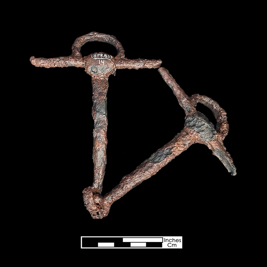
The excavations at 18PR833 revealed a site plan for an inner yard of an early 18th-century plantation. This inner yard was situated to the south of Marbury Road on an upland ridge between Piscataway Creek to the north and Schoolhouse Branch to the south. A dwelling and detached kitchen were present and located just south of Marbury Road. A yard was situated between the two structures. Work-related areas or perhaps buildings were situated between the ridge slope to the south and the domestic and kitchen-related structures to the north. It is possible that such structures as the detached kitchen and work outbuildings also served as quarters for an enslaved workforce. The artifacts associated with the possible outbuildings are similar to those found in features at other areas of the site. However, several agricultural tools (hoes) and livestock-related artifacts (horse bits) were found in these areas as well. This suggests that the outbuildings were used in conjunction with the agricultural focus of the plantation, in contrast to other activities that could have occurred on a plantation (e.g., cloth production, blacksmithing, etc.). Privies or root cellars were located away from the domestic areas near the edge of the site area, and presumably at the yard edge. These areas were also lowest in elevation and down slope from the domestic and kitchen structures. Presumably, if these features represent privies, this placement would have been done for health-related reasons and to reduce odors in the vicinity of the domestic and kitchen structures.
References
2007a Phase II NRHP Evaluation of Site 18PR833 within the Villages of Savannah Development, Prince George's County, Maryland. Greenhorne & O'Mara, Inc. MHT # PR 464.
2007b Phase III Archaeological Data Recovery of Site 18PR833 at the Villages of Savannah Development in Prince George's County, Maryland. Greenhorne & O'Mara, Inc. MHT # PR 532.